January 2026 NSS Projects Update
Technological advances in airspace management and air navigation services bring new challenges and opportunities for the global aviation system. New Southern Sky is our implementation programme to realise the safety, environmental, social and economic potential of these technologies by integrating them into the New Zealand aviation system.
This information is the most recent available at the end of December 2025. It is subject to change and should not be relied upon for planning purposes.
PSR & MSSR radar replacement
The replacement of Airways’ Radar network is underway. Three new co-located Primary Surveillance Radar (PSR) and Monopulse Secondary Surveillance Radar (MSSR) systems are being installed at Christchurch International Airport, Rua-O-Te-Whenua in Auckland, and on Wellington’s Hawkins Hill.
Airways’ existing three PSRs and six secondary surveillance radars are being decommissioned.
MSSR is a contingency for Automatic Dependent Surveillance-Broadcast (ADS-B), New Zealand’s main surveillance system, in the unlikely event of an outage of the global navigation satellite system (GNSS) it relies on. The PSR and MSSR radars will create a new contingency surveillance system with increased system resilience, along the main trunk (Auckland-Wellington-Christchurch).
Project status
- Installation of the new system is complete at Christchurch International Airport and went live in November 2025.
- The existing Hawkin’s Hill radar site in Wellington was deconstructed in April 2025, with the new system now undergoing optimisation. It is currently expected to be commissioned in mid-2026.
- Site preparation is currently underway at Rua-o-te-whenua in Auckland, with the radar installed. Cabling and configuration will commence in January 2026. The new system is currently expected to be commissioned in early 2027.
DVOR/DME installation
Airways is progressing with the installation of Doppler VHF Omni Directional Range (DVOR) and Distance Measuring Equipment DME at eight sites throughout New Zealand.
The installation of these ground-based navigation aids (GBNAs), forms part of the network of technologies which provide a back-up to Airways’ core air navigation and surveillance systems, in the event of a loss of Global Navigation Satellite System (GNSS) navigation capability.
DVOR/DME are GBNA that enable aircraft to complete their approach to an aerodrome and for navigation enroute between aerodromes. They enable aircraft to land safely in lower visibility, increasing safety and efficiency at airports where they are installed. The installation of DVOR/DME ensures a minimum operating network (MON) throughout New Zealand, providing contingency in the unlikely event of a GNSS outage.
DVOR/DME are being installed at the airports in Kaitaia, Whangarei, Tauranga, Taupo, Hokitika, Westport, Alexandra and Timaru.
Only five new installation sites were initially proposed – with three to be funded by Airways and two by the Ministry of Transport. However, the addition of three further MoT funded sites completes New Zealand’s MON. This proves a greater level of coverage and addresses concerns that a more limited network would not allow emergency medical helicopter services to continue operating.
Current project status
- The DVOR/DME equipment has been secured and is in New Zealand.
- Construction will commence on the first site in January 2026 (Timaru).
- Airways is currently expecting the Timaru site to be commissioned in 2026, with all eight sites completed by end-2027.
Domestic Controller-Pilot Data link Communications (CPDLC)
CPDLC is a digital system that lets air traffic controllers and pilots exchange text-based messages for clearances, instructions, and other information, reducing reliance on voice radio for clearer, more efficient communication, especially in oceanic or remote areas. It functions like texting in the cockpit, offering benefits like fewer misunderstandings and less strain on radio frequencies.
CPDLC is currently in operation in Oceanic airspace and Domestic CPDLC is the next step for seamless CPDLC coverage as a service.
Current project status
Domestic CPDLC has progressed with design and operational concepts agreed by stakeholders. The implementation will be spread over time, in parallel with other Airways priorities. Live operations of Domestic CPDLC are expected to occur in FY28.
Satellite Based Augmentation System (SBAS)
New Zealand and Australia are jointly commissioning the SouthPAN Satellite Based Augmentation System. LINZ is the New Zealand lead agency and full details of the system can be found here on the LINZ website:
SouthPAN is a system that will benefit a range of New Zealand industries including aviation. However, the ‘safety of life’ requirements for its use in aviation, allied to performance based navigation (PBN) procedures, mean that its implementation will need to be carefully managed and coordinated.
To that end the NSS SBAS Sub-group, co-chaired by Airways and the CAA continues to support LINZ in the implementation of the aviation related capabilities.
The SBAS Sub-group has provided this latest update on the Draft aviation Safety Implementation plan:
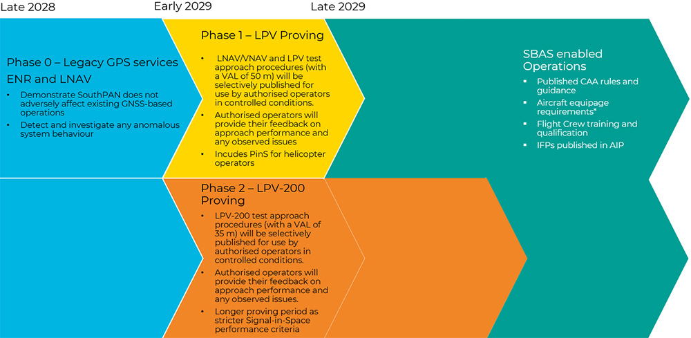
Readers should note that this is a draft plan in December 2025 and is, of course, subject to change. Timing also depends on passing the transition criteria from one phase to the next.
For more information, contact Southpan@linz.govt.nz.